COLLECTION NAME:
David Rumsey Historical Map Collection
Record
Author:
Northern Trust Company
Date:
1928
Short Title:
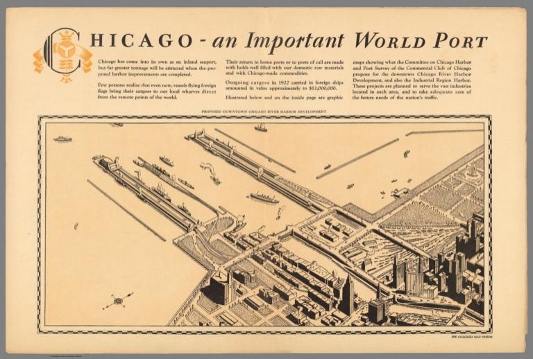
Proposed downtown Chicago River harbor development
Publisher:
Northern Trust Co.
Publisher Location:
Chicago, Ill.
Type:
Case Map
Obj Height cm:
20
Obj Width cm:
40
Scale 1:
None shown
Note:
Color pictorial map, 31x41, on sheet 47x62, folded into 31x23. with pictorial cover. Shows port facilities planned for Calumet area, roads, railroads, place names, parks, etc. Includes text and advertisement for Northern Trust Company. On verso: Text and ancillary aerial view of "Proposed downtown Chicago River harbor development".
State/Province:
Illinois
City:
Chicago (Ill.)
Subject:
Pictorial map
Full Title:
Proposed downtown Chicago River harbor development. (on verso) Pictorial map of Chicago's harbor and industrial region, showing location of important industries, plants, and proposed harbors. With the completion of the deep waterway system this is destined to be the world's greatest industrial section. The Northern Trust Company. (At upper margin) A proposed harbor development to serve and industrial region. (insets) The great Mississippi Valley waterway system. (with) Great Lakes, St. Lawrence deep waterway. (with) Calumet interstate harbor. (Cover title) Pictorial map of Chicago's harbor and industrial region : Complement of the Northern Trust Company ... Chicago.
List No:
11135.002
Series No:
2
Publication Author:
Northern Trust Company
Pub Date:
1928
Pub Title:
Pictorial map of Chicago's harbor and industrial region, showing location of important industries, plants, and proposed harbors. With the completion of the deep waterway system this is destined to be the world's greatest industrial section. The Northern Trust Company. (At upper margin) A proposed harbor development to serve and industrial region. (insets) The great Mississippi Valley waterway system. (with) Great Lakes, St. Lawrence deep waterway. (with) Calumet interstate harbor. (Cover title) Pictorial map of Chicago's harbor and industrial region : Complement of the Northern Trust Company ... Chicago.
Pub Note:
See note field above.
Pub List No:
11135.000
Pub Type:
Case Map
Pub Maps:
2
Pub Height cm:
31
Pub Width cm:
23
Image No:
11135002.jp2
Authors:
Northern Trust Company
Link To Source